Shreveport Weather Forecast: A Challenging Weekend Ahead
The weather forecast for Shreveport and surrounding areas is calling for a challenging weekend, with rain, the potential for ice, and a significant drop in temperatures. A Winter Storm Watch is currently in effect, and residents are advised to stay informed and prepare for the incoming weather conditions.
Rain and Thunderstorms Expected Saturday
Saturday morning and early afternoon will see showers and even some thunderstorms as the first part of the storm system arrives. For most locations, this will primarily be plain rain. However, there is a concern for freezing rain, particularly in northern areas like Vernon Parish, where a significant temperature difference from north to south could lead to freezing rain if cold air moves in quickly enough.
Ice Threat Looms Saturday Night into Sunday
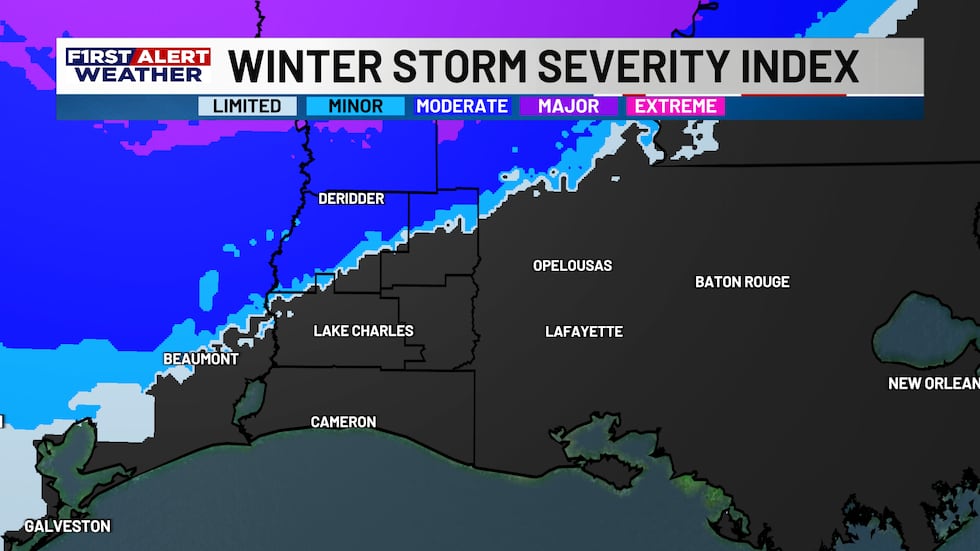
The real concern begins Saturday night and continues into Sunday morning as rain and freezing rain become more likely. The greatest threat of ice accumulation will remain in northern Louisiana, with Vernon Parish facing the highest risk of significant ice buildup. Potential ice accumulations in Vernon Parish could range between three-tenths and half an inch, which could have substantial impacts on roads, power lines, and utilities.
Ice amounts will decrease the farther south you travel. Beauregard and Allen Parishes could see one-quarter to four-tenths of an inch of ice, with the highest totals in far northern parts of the parishes, including areas like Deridder and Oakdale. Totals will drop quickly for the southern parts of these parishes.
Lower Ice Risk in Southern Parishes
In Calcasieu and Jeff Davis Parishes, the odds of ice accumulation are even lower, though a light glaze is still possible if temperatures drop to freezing as precipitation occurs Sunday morning. Even a light glaze of ice can cause issues on bridges and overpasses, so residents should stay alert to how cold conditions become. In Cameron Parish, precipitation is expected to remain as rain throughout the storm.
Arctic Air and Bitterly Cold Temperatures to Follow
After the storm passes, arctic air will move in, bringing bitterly cold temperatures. Monday morning will see wind chills dropping into the single digits across the region, with temperatures ranging from the low 20s to the upper teens. Residents with vulnerable pipes or homes elevated off concrete slabs should take precautions to protect their property from freezing temperatures.
Black Ice Concern Sunday Night into Monday
There is also a chance for black ice to form Sunday night into Monday morning, though this part of the forecast remains uncertain. If winds stay strong enough to push drier air in, the threat of black ice could be limited. However, if winds weaken, black ice will be a more significant concern. Residents will need to stay updated on conditions Sunday to determine the risk of black ice.
What You Should Do to Prepare
With the potential for power outages, hazardous road conditions, and freezing temperatures, it’s essential to prepare now. Here are some steps to take:
- Prepare for potential power outages: Have emergency supplies ready, including flashlights, batteries, and a portable charger.
- Avoid travel: Limit travel Saturday evening through Sunday morning, especially in northern areas where the risk of ice is highest.
- Protect exposed pipes: Insulate pipes or allow faucets to drip to prevent freezing and bursting.
- Check supplies: Ensure you have necessary supplies like food, water, and medications on hand, especially if you live in areas at high risk for ice accumulation.
- Stay tuned to forecasts: Weather conditions can change rapidly, so keep an eye on updates from the First Alert Weather Team.
Stay Safe and Informed
As the winter storm approaches, it’s crucial to stay informed and take proactive steps to ensure your safety and the safety of your loved ones. The First Alert Weather Team will continue to track the latest developments and provide updates as conditions evolve. Remember to check on neighbors, especially the elderly or those with limited mobility, to ensure they are prepared for the incoming weather.
For the most accurate and up-to-date information, follow local news outlets and weather services. Stay warm, stay safe, and prepare for the challenging weather conditions ahead.