Heavy Snow Warning Hits Northeast US: Clipper Storm Alerts
As winter tightens its grip on the United States, a fast-moving clipper system is unleashing heavy snow across the Northeast, prompting widespread winter weather advisories. From the bustling streets of Boston to the rugged peaks of Vermont, residents are preparing for slippery roads and potential travel disruptions. This article dives into the latest forecasts, regional impacts, and safety measures as the storm unfolds on February 10, 2026.
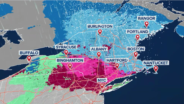
Northeast Clipper System: Snowfall Expectations
The clipper—a quick-hitting low-pressure system racing across the region—is delivering a swath of snow from Upstate New York through New England. Meteorologists at FOX Weather predict widespread accumulations of 1 to 3 inches in lower elevations, enough to create hazardous driving conditions during evening commutes. However, the real drama unfolds in the higher terrain.
In Vermont, New Hampshire, and Maine, elevations above 1,000 feet could see 5 to 8 inches of fresh powder by early Wednesday morning. This boost is welcome news for skiers and winter sports enthusiasts, who have been craving more snow after a variable season. Central New Hampshire and southern Maine are prime spots for these heavier totals, with the forecast favoring ideal conditions for downhill runs at resorts like Killington and Sugarloaf.
Boston and Urban Centers on High Alert
Boston, no stranger to nor'easters, is bracing for another round. City officials have issued warnings for overnight snow, expecting 1 to 3 inches to blanket sidewalks and roads. The Massachusetts Emergency Management Agency urges residents to clear driveways early and avoid unnecessary travel. Similar advisories cover Hartford, Connecticut, where a wintry mix threatens to glaze highways with ice, turning routine drives into potential nightmares.
Upstate New York, from Albany to Syracuse, will also feel the chill, with light snow making bridges and overpasses particularly slick. FOX Weather's latest models show the system moving swiftly, limiting totals but maximizing short-term disruptions. Commuters are advised to check real-time updates via apps like the FOX Weather App for radar and road closures.
Broader US Weather Patterns: From Snow to Southern Storms
While the Northeast digs out, other parts of the country are monitoring related developments. In California, a weak atmospheric river is finally easing the state's "snow drought" in the Sierra Nevada. Mountain peaks could rack up 18 inches or more, providing much-needed water reserves for the spring melt. Coastal areas from San Francisco to Los Angeles will see rain, with totals up to 1 inch, offering relief from ongoing dry spells.
Shifting east, a brewing cross-country storm in the Southern Plains is gaining strength. This system, dubbed the "Valentine's Day storm," promises heavy rain and severe weather risks for the Deep South by the weekend. Portions of the Ark-La-Tex region—Arkansas, Louisiana, and Texas—are on heightened alert for flash flooding, especially on February 14. Confidence is rising for 2 to 4 inches of rain in a short burst, with potential for "training" storms that repeatedly drench the same areas.
Along the I-95 corridor, an arctic thaw is underway after last week's record cold. Temperatures are climbing above freezing, but today's clipper ushers in another pulse of chilly air. New York City officials are warning of falling ice from rooftops and ledges as melting snow poses new hazards. Emergency Management has posted safety guidelines, including avoiding building edges and reporting loose ice to 311.
Flash Flood Threats in the South
The Southern system's track from the Southwest could bring beneficial rain to drought-stricken farms, but the flash flood potential is no joke. Areas like Shreveport, Louisiana, and Texarkana might see rapid rises in creeks and low-lying roads. Meteorologists emphasize that while most rain will be welcome, repeated storm passages could overwhelm drainage systems. Residents should prepare go-bags and monitor NOAA Weather Radio for alerts.
Safety Tips and Preparation Advice
Facing heavy snow or wintry mixes requires proactive steps. In the Northeast, keep an emergency kit in your vehicle with blankets, flashlights, and sand for traction. Clear snow from exhaust pipes to prevent carbon monoxide buildup while idling. For Southern flood zones, elevate valuables and know your evacuation routes—flash floods can surge with little warning.
Professionals recommend checking forecasts multiple times daily, as clipper systems can shift quickly. Apps and local news sources like Everythiiing.com provide live updates to keep you one step ahead. If you're a skier hitting the slopes, verify lift statuses, as fresh snow often means controlled avalanches in backcountry areas.
Looking Ahead: End-of-Week Outlook
As this clipper exits stage left, eyes turn to the weekend's major player—the cross-country storm. It could link up with moisture from the Gulf, amplifying rain in the Southeast and possibly sparking thunderstorms. The Northeast might catch a breather with moderating temps, but another cold front lurks behind.
Weather patterns this February have been unpredictable, blending bitter cold with sudden thaws and storms. Climate experts note that while clippers are typical for the jet stream's winter position, their intensity ties into broader atmospheric shifts. Stay vigilant, bundle up, and let's hope for more powder days than plow-outs.
For the most current details, tune into FOX Weather or visit Everythiiing.com's weather hub. Winter's not done yet—safe travels everyone!